Muskego Historical Society
Historical Markers
Muskego Beach was once the highest class of amusement park. Rides like Bubble Bounce, Screwball, Dodgem’, Tail Spin, Wild Mouse, Walking Charlie, and other attractions filled the air with excitement and thrills. During its peak, a quarter million people, young and old, would visit the park each summer. John C. Schuet opened the Muskego Lake House in 1861 and developed the park for picnicking, fishing, boating, swimming and dancing. William Boszhardt bought the park in 1928, and then Charles Rose built the largest roller coaster in the Midwest with a drop of 75 feet at Muskego Beach. New rides, an arcade and ballroom were added and the bathing beach was enlarged.
Boszhardt died in 1943 and his wife sold the park to Rose in 1945.
Muskego Beach was operated as “DandiLion Park” by Willard Masterson from 1968 until closing May, 1978. Carousel #15 was moved to California and placed in July 1991 at Puente Hills Mall.
Kiwanis Club of Muskego
Waukesha County Historical Society 2000/2001

Muskego Beach Amusement Park
Muskego Beach Amusement Park can be found on north side of Janesville Rd at the Bay Breeze Condo site, west of Muskego Elementary School. 42° 54.407′ N, 88° 8.124′ W
Muskego Victory Garden

Muskego Victory Garden can be found just north of the log cabin (General Store/Trading Post) at the Settlement Building site on Racine Avenue.
Closed
Muskego Centre Station

Muskego Centre Station can be found on Pioneer Drive just south and across the Bike Path from Mather Bowling.
St. Paul's Evangelical Lutheran (Kirche) Church
In 1857, twelve German families started a Protestant Mission church. They brought their Christian faith and German language from the old country to what is now Muskego. Their services were conducted in German and held once a month in a rented, one room, log schoolhouse on Tess Corners Drive.In 1858, the mission congregation bought the land where you are standing and took the name, "The First Protestant Church of Muskego." By spring, a small wooden frame church was built. A reed organ furnished the music while a pot belly stove warmed the congregation in winter. Women and children sat left of the aisle and men on the right, as was the custom back in Germany. Men and women continued to worship separately until 1950. The transition from German to English services came in 1937. German was still used twice a month and on festival occasions. On Maundy Thursday 1949, the final German service was held. The cemetery was established in 1857 with the first burial in 1861. There have been 828 burials since then.

In May 1878, the congregation's first constitution was filed with the Town of Muskego. The name "St. Paul's German Evangelical Lutheran Church" was chosen. In 1890, a schoolhouse (schule) for German religious instruction was built. It is the white building directly in front of you.
In March 1905, the large brick church, to your left, was built and a "Star Tower Clock" was installed in its steeple. By 1911, the congregation had joined the Wisconsin Evangelical Lutheran Synod and English services were held once a month. A used pipe organ was installed in 1919, but someone still had to pump the large five-foot by eight-foot bellows by hand, as electricity had not yet come to Tess Corners.
In 1958, a youth center and playground were built to accommodate the growing Sunday School needs. In September 1968, St. Paul's Lutheran School first opened its doors to fifty-eight students in grades one through five.
In September 1976, a new church was built, and on June 4, 1978, the last regular services were held in the old church. As the congregation filed out that Sunday, each member tolled the old church bell one last time in farewell.
Erected 2014 by Muskego Historical Society and sign donated by Joan Bauman.
Photo by Sue DeAngelis DeLay, February 2025
42° 55.459′ N, 88° 5.651′W It is located just east of Tess Corners Drive on Janesville Road on the south side of the street.
Janesville Plank Road Tollgate
This is the location of an original tollgate located at the Muskego Centre on the Janesville Plank Road; one of 16 privately owned toll roads authorized by the Wisconsin Territorial legislature in 1848. It was to follow a sixty-five mile route beginning in the City of Milwaukee, by way of Big Bend, to East Troy and then to the Village of Janesville. It was to also connect with other plank roads in Wisconsin. It was built on the 1838 Janesville Territorial Road, which followed an Indian trail extending from the rice marshes of Milwaukee southwestwards to Janesville.
The legislature set maximum toll rates that could be levied by the owners of the private road: "tollgates may be erected and tolls collected whenever five miles are finished, not exceeding two cents a mile for every vehicle, sled, sleigh or carriage drawn by two animals, and if drawn by more than two animals, one cent a mile for every additional animal. For every score (10) of sheep or swine three cents a mile and for every score of cattle four cents per mile." It was common practice for farmers to drive their animals to market. Persons exempted from tolls were those going to a required military parade, a funeral or any religious meeting on Sunday. The plank roads effectively cut in half the travel time as compared to the unimproved trails of the day; many of which became totally impassable in the springtime.
By 1854 only 24 miles had been completed near the Forest Home Cemetery in Milwaukee and reaching Mukwonago. Tollgates were at Forest Home Cemetery, Hales Corners, and here at the Muskego Centre, where it intersected with the Waterford Plank Road.
Maintenance costs were quite high as the wood rotted within five years and the profits were not as high as expected. The coming of the railroads in the 1860s was the beginning of the end for this and other plank roads in Wisconsin. As the plank roads were abandoned, they reverted back to the local municipalities for maintenance and upgrading.
Today, Janesville Road still serves the public in much the same way it was intended to over a hundred and sixty years ago.
Erected by the Muskego Historical Society, 2014
42° 54.391′ N, 88° 8.279′ W. Janesville Road on the north side of the street, just east of Pioneer Dr.


Erected 2014 by Muskego Historical Society
Photo by Sue DeAngelis DeLay, February 2025
"Do I Smell a Pizza-Burger?"
This property was originally platted to Anson Taylor by President Martin Van Buren in 1840, then subsequently sold to William Pratt in 1854, this being platted as part of Plattsburg in 1856. In 1866 this property was sold to John Schuet who pioneered Muskego Beach. In 1925 this property was sold to Muskego Beach Amusement Company which subdivided the land into the Muskego Beach Park Addition and became known as lots 19, 20 and 21. In 1938 the original buildings were constructed and operated as a seasonal soda fountain/general store and year-round home by Gilbert and Grace Russe.
In 1946, two childhood friends, Paul (Mus) De Angelis and Hugh (Russ) McGrorty, returning from serving in WWII, decided to go into business together, purchasing this property with the first VA loan issued in the State of Wisconsin.

The original restaurant specialized in homemade custard, burgers and hot dogs, but was soon changed to a drive-in restaurant format; giving birth to the "Big 3 Drive-in." The ever-enterprising pair held other jobs, as the restaurant started out as only seasonal.In 1953, the forward-thinking friends invented the genuine Pizza-Burger sandwich. They incorporated this new venture, therefore starting a long history of genuine Pizza-Burger" sandwich franchising and the creation of Pizza-Burger seasoning. The "often imitated, never duplicated" genuine Pizza-Burger" sandwich sold coast-to-coast, including Canada. At one point, over 1500 accounts served the genuine Pizza-Burger sandwich. This family-owned business was overseen from a one-room structure built around an original outdoor barbecue area. The "Big 3 Drive-In" thrived throughout the 1950s and 1960s, serving locals and visitors to Muskego Beach/Dandilion Park, as well as to cruisers and musicians, deeming the drive-in "the place" to hang out.In the mid 1970s, Paul brought out his longtime partner, Russ, changing the drive-in to a family style restaurant. "Muskego Restaurant" continued to operate until 1993 when the De Angelis family decided to sell this property. Following the sale, this property was home to a butcher shop, day care, and floral boutique.Pizza-Burgers may no longer be served on this site, but Pizza-Burger System, Inc. is proud to remain a part of the Muskego fabric, successfully managed by the second and third generations of the De Angelis family.
Erected 2014 by Muskego Historical Society, sign donated to the Citizens of Muskego by
David L., Tracy K. and Julia M. DeAngelis
Photographed by Sue DeAngelis DeLay, February 2025
42° 54.43′ N, 88° 8.01′ W At the corner of Janesville Rd. and Park Drive.
The Devil's Teapot
In 1904, the coming of the interurban electric railway (TREM&L) made railroad travel possible between downtown Milwaukee and East Troy, WI. At this very location, a railroad trestle was constructed to bridge a two-acre pond/waterhole in a pasture on the Kingston farm. It appeared to be just an ordinary little farm pond where a person could catch bullheads and carp in the 20-foot deep marsh bordering the pond. A 200-foot long trestle was built over the sinkhole, but as interurban cars passed over it, strange groaning and gurgling sounds came from the trestle. John I. Beggs, supervisor for the TREM&L system nicknamed it the "Devil's Teapot."
On Friday morning, April 20,1917, after a westbound interurban car had just passed over it, the trestle collapsed into the sinkhole. From
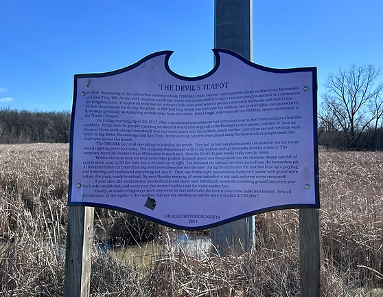
then on, people traveling westbound would have to get off at the Muskego Centre station, just east of here on Pioneer Drive, walk along a boardwalk that was constructed over the sinkhole, board another interurban car and continue westward to Big Bend, Mukwonago and East Troy. In the evening, lanterns were placed along the boardwalk so people could find their way across the marsh.
The TMER&L Co. tried everything to stabilize the trestle. They laid 16 foot oak planks across the sinkhole but the water oozed right up over the tracks. The company then decided to fill in the sinkhole and lay the tracks directly across it. The company hired 26 workers from Milwaukee to work on it. Now the Devil's Teapot would really earn its name.
Within the next year various items were pushed, dumped, tossed and disappeared into the sinkhole. Dump cars full of gravel were used to fill the hole, but it all sank out of sight. Ten thousand old railroad ties were sucked into the bottomless pit. A thousand hand-cut trees from Big Bend were deposited into the hole. During the entire year the sinkhole kept up a gurgling and bubbling and swallowed everything fed into it. Then, one Friday night, seven railway dump cars loaded with gravel were left on the track, ready to unload. By next Monday morning, all seven had rolled in and sunk and were never recovered!
A year later the sinkhole was finally filled in and tracks were laid directly across the trembling ground, but every year the tracks would sink, and every year the workers had to raise the tracks another foot.
Finally, as modern highways were improved for cars and trucks, the electric interurban faded into history. Now all that remains of the legend is the roadbed that you are standing on and the story of the DEVIL'S TEAPOT
Erected in 2014 by Muskego Historical Society.
Photo by Sue DeAngelis DeLay, 2025
42° 54.03′ N, 88° 8.811′ W On the bike path going east from Racine Av. just south of Janesville Rd and Racine Ave. The bike path is across the street from Culver's.
Park Arthur
This city park is named in honor of Arthur Henry Thiesenhusen (1898-1990) by his wife Myrtle. He farmed this land until his retirement in 1966. Arthur was the son of William Johann and Henricka "Ricka' (Garbe) Thiesenhusen - both early immigrants to Waukesha County. The Thiesenhusens were from Rosenow, Mecklenburg, Germany and arrived in 1853. They established their latest dairy farm on the north side of College Avenue in 1880, adding this land in Muskego in 1911. Arthur built a colonial style home on his land in 1934 as a gift to his new bride Myrtle Honeyager, and raised four sons who attended Muskego schools. The southernmost portion of this park was once part of the Ralph Martin family farm. The city of Muskego purchased the land in 1997 and opened the park to the public in 2013.
Erected in 2013 by The Arthur H. Thiesenhusen Family
42° 55.666′ N, 88° 8.069′ W The park can be accessed from College Av. or Martin Drive. The marker is near the shelter.
Linnie Lac
55.802′ N, 88° 9.061′ W.
Linnie Lac-included as part of Muskego in the early settlement years, this marker is just inside New Berlin on College Avenue between Preston Dr. and Gold Dr.
Formerly called Hale’s Mill Pond
Near this site, 1836-’37, Waukesha County’s first dam and sawmill were built by Hugh Wedge and Isaac DeWitt. In 1840 Wedge sold out to William P. Hale, who was joined by his brother, Hiram E. Hale in 1846. Hiram bought out William in 1855, and operated his mills to the 1890’s. Four water powered saw, grist and flouring mills and 4 steam powered flouring mills operated here and spurred development of the Yankee Settlement here and nearby Prospect Hill. Hale’s Mill Pond was the place to fish, swim, hold skating parties and ice cutting bees, inspiring the area’s name of “Mill Valley.” In the 1920’s John C. Blott, a descendant of early settlers, subdivided the Mill Pond’s shores, and renamed it Linnie Lac to honor his wife, Malinda Hotelling Blott, whose nick name was “Linnie.”

Old Muskego Town Hall
Muskego’s only town hall was built in 1921 for community purposes. From 1842, town meetings and elections were in homes, school houses and saloons.
Here also, were farm and Legion meetings, “socials”, Sunday school, library, graduations, first aid and cooking classes, anniversaries, a funeral. It was interim City Hall, 1964-72 restored by Muskego Fine Arts Association, 1976.
Erected by the City of Muskego, 1976.
Photo by Sue DeAngelis DeLay
42° 53.883′ N, 88° 8.688′ W. The Old Town Hall is on Racine Avenue south of Janesville Rd on the grounds of the Muskego Settlement Centre.

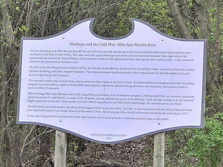
Muskego and the Cold War: Nike Ajax Missile Base